


hiking group
As part of our circle of friends, we plan to regularly offer hikes in the area surrounding Eschdorf.
The next dates can be found in the event schedule.
The meeting point is always the parish courtyard of St. Barbara Church in Eschdorf.
Hiking concept from Eschdorf
The Eschdorf Friends Association (Freundeskreis Eschdorf eV) created a concept for the hiking trails around Eschdorf in 2021. You can download this map here.
Discover nature
Hiking tours in Eschdorf

Eschdorfer circular trail 1

Eschdorfer circular trail 2
Eschdorfer Rundweg 3
Eschdorfer Rundweg 4
Our hike begins at the historic Eschdorf rectory, Kirchberg 3 in 01328 Dresden-Eschdorf, a four-sided farmstead with buildings dating from the 18th and 19th centuries (former servants' quarters – now hikers' accommodation, small barn, large barn – now a cultural center, and rectory). These buildings were restored in the regionally typical half-timbered style after German reunification. We leave the rectory along the historic cemetery wall made of sandstone blocks and turn right at the outside of the cemetery gate, passing the cultural center on our right, and immediately turn left onto a gravel path leading to the former railway embankment of the Weißig – Dürrröhrsdorf branch line. Here we turn left onto this now-paved cycle path and follow it to the former Eschdorf stop, which lost its function in 1951 with the dismantling of this regional railway and now houses a hikers' hut rebuilt in 2007. Here we turn right onto a paved path belonging to the former agricultural cooperative (LPG) and hike uphill for approximately 1 km. Along this path, we have a wide view to the left as far as Stolpen Castle. Reaching the edge of the forest, we turn left onto a dirt track into the woods (now marked with a green dot).
After a few meters, the path marked with a green dot leaves us, but we continue straight ahead. After several hundred winding meters downhill, we reach a forest path junction and meet the old hunting trail of Augustus the Strong. We turn left onto this "High Bridges Trail" (also called the "Seven Bridges Trail") and cross the first and, for us, only one of the High Bridges today. Now we follow the green-marked path uphill in long curves and arrive at beautiful, alpine-like mountain meadows. Our path now leads us to the Doberberg, a 292-meter-high hill above Wünschendorf with a rest area, a tall, visible summit cross, and a war memorial. From here, we have a sweeping view of Saxon Switzerland and Pirna, as well as the so-called "Schöne Höhe" (Beautiful Height) near Dittersbach. Now our hike turns back a few hundred meters until we reach a crossroads and continue straight ahead (it is the Schönfeld-Weißiger-Bergweg (SWB) marked with a green dot), which we follow across meadows and into a light forest until we reach the point where we turned into the forest from the old paved path almost at the beginning of our hike.
Here at the edge of the forest, we leave this SWB trail (marked with a green dot) and turn right back onto the paved path leading down to Eschdorf. At the Eschdorf train stop, we turn left onto the current long-distance cycle route back to the Eschdorf rectory, which is visible from afar thanks to the adjacent St. Barbara Church, dating from 1346. Those wishing to make a short detour into the Eschdorf manor park with its ancient trees should turn right about 100 meters past the Eschdorf train stop onto a somewhat bumpy path leading down into the park's valley. From there, they can also reach St. Barbara Church and the Eschdorf rectory. The Eschdorf church was rebuilt in 1886 by Traugott Bienert, the owner of the local mill, who was born at the Eschdorf Upper Mill. The small, interesting Herbrig organ with its organ case by Gottfried Semper, the St. Barbara altar, and the late Gothic cross vault in the chancel invite visitors to linger. The upper floor of this church also houses the "Museum in the Attic," a local history museum for the region around Eschorf.
Our tour begins in front of the "Wurschtelpeter" butcher shop, where you can fortify yourself with some food and drink. Refueled, we continue along Spiegelweg for about 250 meters to the bench "Am Kalkhaufen" (At the Lime Heap), where we turn right onto the dirt track and follow it until just beyond a pond, which we leave to our left. Our path now splits at Gickelsberg, and this time we take the right-hand dirt track, which winds gently uphill (the left-hand path leads as a sunken lane through a former sand pit). At its highest point next to Gickelsberg, our path offers a panoramic view, stretching from Eschdorf across Stolpen Castle and deep into Lusatia. We continue along this path, initially in a wide left-hand bend, then turning right, between fields, until this hiking trail joins the "Alte Rossendorf-Dittersbacher Straße" (Old Rossendorf-Dittersbach Road). Here we turn left towards Alt-Rossendorf. Along the right-hand side of the forest edge, we are accompanied by some very old sweet chestnut trees (marrons). Shortly before Rossendorf, we see a recently remediated former landfill on the right and then, leaving the Rossendorf riding stables to our right, we reach the busy S 177 (Pirna-Radeberg) road.
Directly at this junction, we see a triangular old sandstone block on the right-hand side of the roadside ditch (about 30 meters further on, we find a similar stone). Both sandstone blocks originate from the old courtyard entrance of the former Rossendorf manor, which burned down completely in the 1830s and was rebuilt on the opposite hill under the later owner of the manor, von Quandt. Its small tower is easily recognizable from a distance. We cross the S 177 diagonally to the left and after a few meters turn right onto the "Alte Schullwitz-Rossendorfer Straße" (Old Schullwitz-Rossendorf Road), which is now only used for agricultural traffic. We follow this road, which offers a beautiful view of the Triebenberg hill and parts of Eschdorf and Schullwitz, until it becomes a concrete slab path built during the GDR era. From here, one could continue hiking to the Napoleon Stone and on to Weißig. At the beginning of the slab path, we turn left and reach the village of Schullwitz via an old village road. Here we turn left along the road from Weißig, until we reach the "Am Triebenberg" inn in Schullwitz, where a tasty and inexpensive meal tempts us to stop for a break.
At this inn, we turn left onto the asphalt road towards Eschdorf and follow it until we reach the container yard, which soon becomes visible. We then leave the road and immediately turn right behind the containers onto the former railway embankment of the Weißig-Dürrröhrsdorf line, which has been out of service since 1951 and is now used as a cycle path. At the Schullwitz-Eschdorf station, which follows shortly after, many relics still recall the former railway operations. We continue along this cycle path, past the houses of Eschdorf, until we see two football goals on the left, then the Eschdorf church, and finally a display case on the railway embankment. We turn left in front of this, keeping the cemetery wall to our right, and walk through the rectory grounds down into the Schullwitzbach valley, past a playground, to the traffic lights at the S 177. We cross at the lights and can already see the "Wurschtelpeter" butcher shop, where our hike ends.
Our hike begins at the Eschdorf parish churchyard next to St. Barbara's Church (first documented in 1346). We leave the churchyard between the cemetery wall and the cultural barn, turn immediately right, and then immediately left again, walking along the edge of a meadow used as a volleyball and soccer field to the old railway embankment of the former Weißig-Dürrröhrsdorf railway line. We turn right onto this path, now used as a cycle and hiking trail. After about 500 meters, we leave this asphalt path to the left and turn onto the "Schönfeld-Weißiger-Bergweg" marked with a green dot. We climb the Triebenberg, Dresden's highest hill (383m), between fields. After reaching its summit at the edge of the forest, our hiking trail leads us downhill again until, after a left-hand bend, we reach a concrete path (the former access road to the Soviet Army's radar station and later a research laboratory of the TU Dresden). We turn right onto this path and continue downhill. The concrete path meets the Eschdorf-Zaschendorf paved path belonging to the agricultural cooperative.
Now we turn right and walk about 100 meters along this path until the marked field path to Zaschendorf branches off to the left. We continue on this path until we reach Zaschendorf. To the right, we see the former mill and not far from it, the miller's house (distinctive is the wooden cross in front of it). From Friday to Sunday, between 1:00 pm and 6:00 pm, you can enjoy delicious cakes, coffee, and ice cream in the café there. Once in Zaschendorf, we turn right onto the village street and walk to the village square with its hand pump. We turn left there and after a short walk reach the Schuster family's cultural center, where you can buy handcrafted items made of metal and wood, and on some days, coffee and cake. We continue past the blue house out of Zaschendorf, enjoying the beautiful view of Saxon Switzerland, until our path forks.
Here we turn left onto the narrower path marked towards Doberberg. On this now longer marked section through the forest, we cross the so-called Seven High Bridges, hunting paths dating back to the time of Augustus the Strong, which were intended to facilitate his carriage journeys through the rugged forest. After a while, we reach a marked fork in the path in the woods. Here, we turn left twice in quick succession to reach the path to Eschdorf. We ascend this path again and after about 1 km reach the Eschdorf-Zaschendorf paved path belonging to the agricultural cooperative. We turn right onto this path and continue towards Eschdorf. In front of the Eschdorf train station, we turn left onto the former railway line. After a few meters, the path to the Eschdorf Manor Park branches off to the right (marked with a sign). We, however, continue straight ahead until we reach a large display case belonging to the Eschdorf parish. Behind this we turn right, see St. Barbara's Church again and return to the Eschdorf parish courtyard.
The hike begins in the forecourt of the Eschdorf butcher shop "Wurschtelpeter," where you can enjoy a good meal and drinks beforehand, and then set off refreshed on this approximately 10 km tour. The route leads for about 400 meters along Spiegelweg. At the bench "Am Kalkhaufen" (as it says on the backrest), turn right onto the dirt track and follow it for about 800 meters. Approximately 100 meters past a fish pond on the left, you'll reach the terminal moraine hills of the Gickelsberg. Here, the route leads you along the edge of the bushes, through the sunken lane of a former sand pit, and into the woods to a large meadow at the edge of the forest. Follow the path trampled into the grass to the left, then after a short distance, turn right and you'll meet a rutted dirt track on the right. Follow this track straight ahead for about 500 meters, leaving a small range of hills to your left. At the end of this path, we meet the old "Rossendorf-Dittersbacher Weg" (Rossendorf-Dittersbach Road) in a slight right-hand bend. We turn right onto this road and follow it for several kilometers until its end just before Dittersbach, passing the old Dittersbach brickworks (now a concrete block factory) on our right. Along this stretch, we have wonderful panoramic views of Eschdorf and the Triebenberg hill in the background. Shortly before Dittersbach, we reach the paved Eschdorf-Dittersbach road, which we turn right onto and then exit again on the left after about 50 meters.
Our path now leads us along a meadow trail to just before the edge of the forest in the Lieblingstal valley. Here, the path forks in the meadow. We turn left onto the meadow path towards the valley and, at the end of this path, pass the first allotments of Dittersbach before reaching the beginning of the Lieblingstal valley. Here, we turn right onto the hiking trail through the Lieblingstal valley and immediately arrive at the Hubertus Chapel. This chapel, along with other benches and memorial steles along the way, was erected around 1830 by Baron von Quandt, the then landowner of Dittersbach and Eschdorf, in honor of the Saxon royal family and lovingly restored between 2000 and 2006 by the Dittersbach Quandt Association. Our path leads us over several bridges spanning the Schullwitzbach stream, through the forest and then across meadows to the Devil's Bridge. Shortly before reaching the bridge, the path forks, and unfortunately, the signposts end. Shortly after the last bench we passed, turn right at the junction and continue through the woods to the edge of the forest. Here, continue along the edge of the woods to the left (unfortunately, the path is now in poor condition for about 120 meters!). We come to a farm track emerging from the woods; turn right onto this track and continue until you reach the paved Dittersbach-Eschdorf road, where you turn left at the end of the path.
(ATTENTION: From the partially missing section of the path along the forest to the entrance of Eschdorf, road construction work for the new S 177 expressway will be underway in the near future. As a result of this work, these missing and partially rutted paths will be repaired or completely rebuilt!) We hike along the paved road past the Rosinendörfchen (Raisin Village) to Eschdorf and turn right at the end of this road onto the footpath of the old S 177. Our hike leads us past the former Landei inn to the Bienertmühle (Bienert Mill) in Eschdorf, diagonally opposite. This is the place where the mill owner Traugott Bienert was born and, as a young man, began his successful career as a miller and mill owner. (After consulting with the owners of this mill, it is possible to view the old, partially preserved mill machinery.) Afterwards, our path leads us a few meters uphill (at the top, we can see the school and church of Eschdorf). But we immediately turn right onto Mühlenweg, which was built on the former mill stream, past the Eschdorf playground back to the butcher shop “Wurschtelpeter”, which we can already see from afar and where, perhaps after another refreshment, our hike ends.
This hike takes us along the old "Leuschnerweg" trail into the Harthwald forest and back. We begin our walk at the Eschdorf parish church by St. Barbara's Church and descend Kirchberg hill in Eschdorf to Pirnaer Straße, which we cross at the traffic lights. Passing the "Wurschtelpeter" butcher shop, where we can refresh ourselves, we continue along Spiegelweg, under an old passageway of a now-converted barn, until we reach the junction at the "Bank am Kalkhaufen" (Bench by the Lime Pile). Here we turn right and continue along this farm track for about 1.5 km, past the construction site of the new S 177 highway and a small pond, uphill, past a bench with a beautiful view of Lusatia, then further down the slope to the left. This path winds through fields until it meets the old Rossendorf-Dittersbach road, onto which we turn right. Now we walk about 500 meters until a (relatively new) gravel path begins on the left, which we follow for about 300 meters, in order to then reach the old, somewhat bumpy "Leuschnerweg" on a footpath, which unfortunately has been somewhat damaged by riders and is also slightly overgrown.
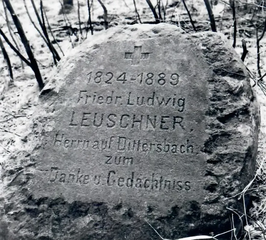
Now we continue straight ahead, past four old boundary stones between the former estates of Dittersbach and Rossendorf, until we reach the small stream "Der kalte Bach" (The Cold Brook), whose bridge unfortunately collapsed during the 2013 floods. We must therefore cross the stream using a log laid across the path or a nearby small ford. In the near future, a public ford with stepping stones in the stream and a rest area on the opposite bank, featuring the re-erected Leuschner Stone, will welcome hikers at this location. Friedrich Ludwig Leuschner, a member of the Reichstag born in Glauchau, owned the manors of Dittersbach and Rossendorf from 1883 until his death and is said to have advocated for the conversion of Saxon forests from monoculture to mixed woodland as early as the end of the 19th century. We continue our hike on the other side of the "Kalter Bach" until we reach the road in front of the gate of what is now the Helmholtz Centre. The Leuschner memorial stone currently exists hidden on the outside of the fence of the Helmholtz Centre, where it was moved during the construction of the former ZfK during GDR times.
We reach this spot from the road by walking directly along the fence, crossing the "Kalten Bach" (Cold Brook) once more. We return along the same path to the road, which we follow until we reach the "Dürrröhrsdorf-Ditterbach" village sign. Immediately after, we turn right onto a farm track, which again crosses the "Kalten Bach". Our path leads to the right shortly before a small wood. We leave this wood behind, cross the next field (meadow on the right, field on the left) until just before another small wood. Before reaching the next wood, we continue along the farm track to the left, following it until we rejoin the old Rossendorf-Dittersbach road. We turn right onto this road and follow it until our path back to Eschdorf, the one we started on, leads off to the left. In the future, the construction of the new S 177 will restore a new route from the old Rossendorfer-Dittersbacher Straße to the Eschdorfer Rosinendörfchen, which would then be a good option as a return route.